Henley Beach
Location
Henley Beach is a coastal suburb, located in the City of Charles Sturt council area. It lies between the suburbs of West Beach and Grange.
Demographics
Population; 5,997
Average age; 40 to 49
| Owns outright | Purchaser | Renting | Other | Not stated |
|---|---|---|---|---|
| 34% | 32% | 32% | 1% | 2% |
| Childless Couples | Couples with Children | Single Parents | Other |
|---|---|---|---|
| 39% | 47% | 12% | 2% |
Market Insights

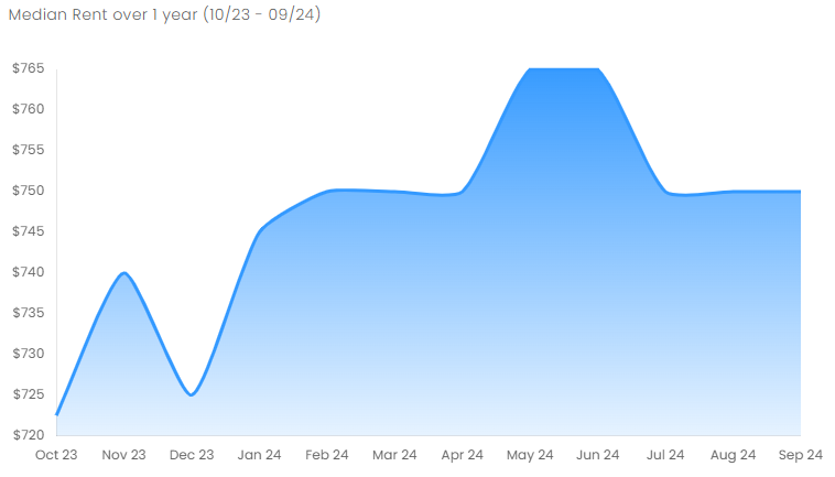
Rental Statistics
Click here to view the rental statistics report for Jul-Sep 24
Click here to view the rental statistics report for Apr-Jun 24
Click here to view the rental statistics report for Jan-Mar 24
Click here to view the rental statistics report for Jun-Sep 23
Click here to view the rental statistics report for Sep-Dec 22
Click here to view the rental statistics report for Jun-Sep 22
Click here to view the rental statistics report for Mar-May 22
Click here to view the rental statistics report for Dec-Mar 22
Click here to view the rental statistics report for Sep-Dec 21
Click here to view the rental statistics report for Jun-Sep 21
Schools
Local schools for Henley Beach;
- Fulham North Primary School (R-7)
- Henley High School (Yrs 8-12)
- Fulham Gardens Primary School (R-7)
- St Michael's College - Secondary Campus (R-12)
- Star of the Sea School (R-6)
Parks
Henley Square is located behind Henley Jetty on the Esplanade. Other greenspace in the suburb is the Henley Grange Memorial Oval and John Mitchell Oval. Henley Beach extends the length of the suburb.
Transport
Henley Beach is serviced by Grange Road and Henley Beach Road, both connecting the suburb to the Adelaide CBD. Seaview Road runs along the coast.
Henley Beach is serviced by public transport run by Adelaide Metro, which provides bus services to the Adelaide CBD and Glenelg. The Grange railway line was extended to Henley Beach.
* Information is accurate as of September 2021 and provided by;
Australian Bureau of Statistics
RP Data CoreLogic