Location
Glandore lies in the south-west of Adelaide, partly located in the City of Marion and partly in the City of West Torrens. It is bordered by Anzac Highway (north), Cross Road (south), South Road (east), and Beckman Street and Winifred Avenue (west).
Suburbs surrounding Glandore include Edwardstown, Black Forest, Everand Park, Kurralta Park and Plympton.
Demographics
Population; 2,963
Average age; 20 to 29
| Owns outright | Purchaser | Renting | Other | Not stated |
|---|---|---|---|---|
| 28% | 33% | 35% | 2% | 3% |
| Childless Couples | Couples with Children | Single Parents | Other |
|---|---|---|---|
| 34% | 47% | 15% | 3% |
Market Insights

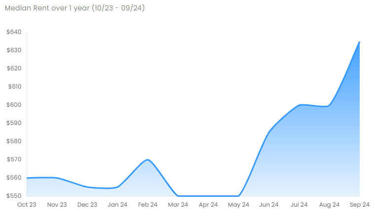
Rental Statistics
Click here to view the rental statistics report for Jul-Sep 24
Click here to view the rental statistics report for Apr-Jun 24
Click here to view the rental statistics report for Jan-Mar 24
Click here to view the rental statistics report for Jun-Sep 23
Click here to view the rental statistics report for Jan-Mar 23
Click here to view the rental statistics report for Sep-Dec 22
Click here to view the rental statistics report for Jun-Sep 22
Click here to view the rental statistics report Mar-May 22
Click here to view the rental statistics report for Dec-Mar 22
Click here to view the rental statistics report for Sep-Dec 21
Click here to view the rental statistics report for Jun-Sep 21
Schools
Local schools for Glandore;
- SEDA College SA
Transport
The Glenelg tram line runs through the middle of the suburb, with stations at South Road, Burke Street and Beckham Street. Adelaide Metro buses also travel regularly through the suburb.
Parks
A number of parks are located within the suburb boundaries including Glandore Oval, Jubilee Park and the shared grounds of the Glandore Community Centre.
* Information is accurate as of September 2021 and provided by;
RP Data CoreLogic