Local Information
Location
Colonel Light Gardens is a suburb located within the City of Mitcham, approximately 7kms south of the Adelaide CBD.
It is bounded by Goodwood Road to the east, Grange Road to the north, Goodwood Road to the west, and Springbank Road to the south. Suburbs of Westbourne Park, Lower Mitcham, Clapham and Panorama make up the boundaries.
Demographics
Population; 3,365
Average Age; 40 to 49
| Owns outright | Purchaser | Renting | Other | Not stated |
|---|---|---|---|---|
| 37% | 48% | 12% | 1% | 1% |
| Childless Couples | Couples with Children | Single Parents |
|---|---|---|
| 30% | 59% | 11% |
Market Insights
 .
.
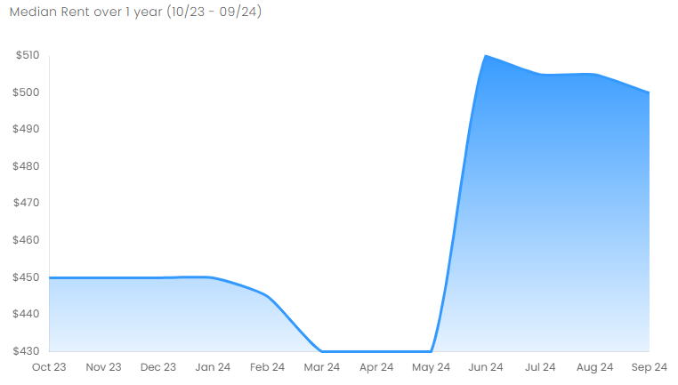
Rental Statistics
Click here to view the rental statistics report for Jul-Sep 24
Click here to view the rental statistics report for Apr-Jun 24
Click here to view the rental statistics report for Jan-Mar 24
Click here to view the rental statistics report for Jun-Sep 23
Click here to view the rental statistics report for Jan-Mar 23
Click here to view the rental statistics report for Sep-Dec 22
Click here to view the rental statistics report for Jun-Sep 22
Click here to view the rental statistics report for Mar-May 22
Click here to view the rental statistics report for Dec-Mar 22
Click here to view the rental statistics report for Sep-Dec 21
Click here to view the rental statistics report for Jun-Sep 21
Schools
Local schools for Colonel Light Gardens;
- Colonel Light Gardens Primary School (R-7)
- St Therese School (R-6)
Fun Facts
It is well known for its wide, tree-lined streets, presentable postwar bungalow homes, rounded street corners and lots of manicured, well maintained open space.
The suburb has an unusual layout - when viewed from the air, part of the suburb is said by some to resemble the rising sun symbol of the Australian military, and by others to resemble a Union Flag. However, it was not designed this way.
History
The part of the suburb east of Goodwood Road was used as an army training camp during World War I, and prior to this the area was known as Grange Farm.
The suburb contains many well preserved bungalow homes, and in October 1999 was placed on the Register of The National Estate. In 2000 the suburb was declared a State Heritage Area; for the heritage significance of Colonel Light Gardens.
Transport
The suburb is serviced by Adelaide Metro buses along Goodwood Road, East Parkway, Grange Road and Springbank Road.
The closest railway stations, Mitcham and Torrens Park on the Belair railway line, are situated some distance to the east on Belair Road.
* Information is accurate as of September 2021 and provided by;
RP Data CoreLogic