Location
Myponga is a outer southern suburb of Adelaide, located in the District Council of Yankalilla. It is a 60km drive to the Adelaide CBD
Demographics
Population; 744
Average Age; 50 to 59
| Owns outright | Purchaser | Renting | Other | Not stated |
|---|---|---|---|---|
| 26% | 56% | 14% | 1% | 3% |
| Childless Couples | Couples with Children | Single Parents | Other |
|---|---|---|---|
| 39% | 48% | 10% | 2% |
Market Insights

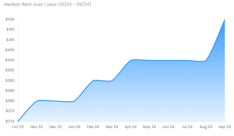
Rental Statistics
Click here to view the rental statistics report for Jul-Sep 24
Click here to view the rental statistics report for Apr-Jun 24
Click here to view the rental statistics report for Jan-Mar 24
Click here to view the rental statistics report for Jun-Sep 23
Click here to view the rental statistics report for Sep-Dec 22
Click here to view the rental statistics report for Jun-Sep 22
Click here to view the rental statistics report for Mar-May 22
Click here to view the rental statistics report for Dec-Mar 22
Click here to view the rental statistics report for Sep-Dec 21
Click here to view the rental statistics report for Jun-Sep 21
Schools
Local schools for Myponga;
- Myponga Primary School (R-7)
History
Myponga began as a settlement as a series of land purchases on section 521 of the cadastral unit of the Hundred of Myponga in 1858. Iin 1939, a sub-division was laid out on part of Section 521.
Boundaries for the locality were created on 5th of August 1999.
Myponga Reservoir
The reservoir is fed by the Myponga River and other rivers in the Myponga catchment. It provides about 5% of the City of Adelaide's water supply and is the main source of filtered water for southern metropolitan Adelaide and the southern coast area.
Plans to use the Myponga River catchment as a major storage area were made in 1945, construction began in 1958 and was completed in 1962.
* Information accurate as at September 2021 and provided by;
RP Data CoreLogic
-
Education
- Myponga Primary School
-
Recreation
- Nixon-Skinner Conservation Park
- Yulte Conservation Park