Local Information
Location
Christies Beach is a seaside suburb in the southern Adelaide metropolitan area, within the City of Onkaparinga. The area is scenic and popular with photographers as Witton Bluff provides a vantage point over the entire suburb and beyond.
It is adjacent to the suburbs of Christie Downs and Noarlunga Centre to the east, Port Noarlunga to the south, and O'Sullivan Beach to the north.
Christies Beach is bounded by Christie Creek in the north, Dyson Road in the east, Mills Avenue, Bice Avenue, Fenton Avenue & Dale Avenue in the south and Gulf St Vincent in the west.
Just a short 30km to the Adelaide CBD.
It has 17 parks covering nearly 7.2% of the total area.
Demographics
Population; 5,457
Average age; 20 to 29
| Owns outright | Purchaser | Renting | Other | Not stated |
|---|---|---|---|---|
| 29% | 25% | 43% | 1% | 3% |
| Childless Couples | Couples with Children | Single Parents | Other |
|---|---|---|---|
| 40% | 32% | 27% | 2% |
Market Insights

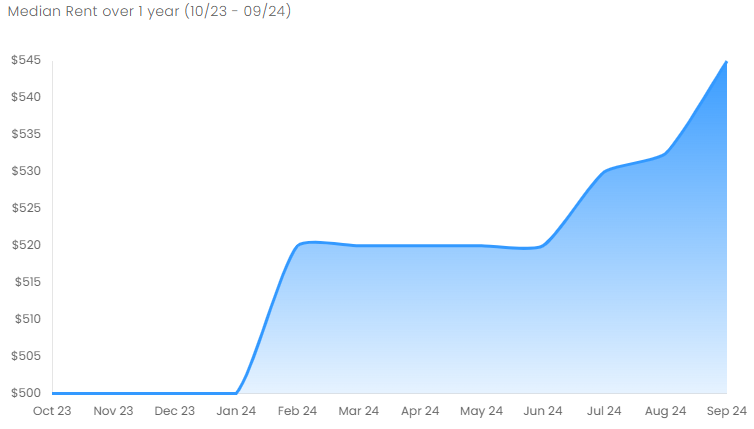
Rental Statistics
Click here to view the rental statistics report for Jul-Sep 24
Click here to view the rental statistics report for Apr-Jun 24
Click here to view the rental statistics report for Jan-Mar 24
Click here to view the rental statistics report for Jun-Sep 23
Click here to view the rental statistics report for Jan-Mar 23
Click here to view the rental statistics report for Sep-Dec 22
Click here to view the rental statistics report for Jun-Sep 22
Click here to view the rental statistics report for Mar-May 22
Click here to view the rental statistics report for Dec-Mar 22
Click here to view the rental statistics report for Jun-Sep 21
Schools
Local schools in Christies Beach;
- Christies Beach Primary School (R-7)
- Bowden Brompton Community School - Beach Campus
- St John the Apostle Catholic School
History
The first European development along the Christies Beach coastline was constructed in the 1830s - a whaling station was constructed. By the 1840s the seasonal whale population dwindled down to unprofitable levels, and the whalers left the area to pursue other activities.
In 1895 Lambert Christie and his wife Rosa established a farm that covered the area where Christies Beach is now situated. The entire land remained farming land up until 1923 - this is when Rosa Christie created the first subdivision in the area. Christies Beach became a tourist and holiday makers destination who were looking for a coastal experience - many tourists decided to build cottages and holiday shacks.
With the influx of visitors and new residents to the area, the Christies Beach Progressive Association was formed to provide good foreshore amenities. Foreshore developments led to the creation of new shops and services on the Esplanade and nearby Gulfview and Beach Roads. By the 1950s demand for residence in the area skyrocketed, and this propelled commercial and industrial developments in the Lonsdale district. This included the opening of Port Stanvac Oil Refinery and Chrysler (later Mitsibishi) engine plant, and also in Noarlunga with the relocation of the railway line and construction of Colonnades Shopping Centre.
Sport
The central sporting hub for the Christies Beach area is the John Bice Memorial Oval, home of the Christies Beach Football Club, Southern Districts Cricket Club and the Christies Beach Sports and Social Club.
Historical Sites
The Morrow Road Bridge over Christies Creek, a Local Heritage place, was once the main road bridge linking Christies Beach to O'Sullivan Beach. The structure is thought to be the only remaining example of a wooden road bridge in the former Noarlunga Council area.
Future Deveopment
Existing foreshore developments include toilet facilities, benches, shelter, barbecue facilities, native vegetation plantations, fencing, informational signage, beach access stairs and paved footpaths on both sides of the Esplanade. Recently, all overhead power lines along the Esplanade have been converted to underground power lines to improve scenic value of the foreshore.
There are also plans in the future for a coastal trail from Christies Beach to Port Noarlunga, with the application for funding being considered.
* Information is accurate as of September 2021 and provided by;
Australian Bureau of Statistics
RP Data CoreLogic
-
Education
- Christie Downs Primary School
- Christies Beach High School
- Christies Beach High School West Section
- Christies Beach Primary School
- Christies East Primary School
- Noarlunga College of TAFE
- Noarlunga Community College of TAFE
- O’Sullivan Beach Primary School
- Port Noarlunga Primary School
- St Johns School
-
Recreation
- Asor Park Reserve
- Christies Beach Caravan Park
- Karingal Reserve
- Onkaparinga River Recreation Park
- Port Noarlunga Aquatic Reserve
