Seaford Heights
Location
Seaford Heights is located south of Adelaide and lies within the City of Onkaparinga. Its boundaries are formed by Robinson Road on the north, Main South Road on the west, Victor Harbor Road & Ostrich Farm Road on the east, and The Southern Waste Depot on the south. It covers 77 hectares.
Demographics
Population; 52
Average age; 20 to 39
| Owns outright | Purchaser |
|---|---|
| 19% | 76% |
| Childless Couples | Couples with Children |
|---|---|
| 59% | 18% |
Market Insights

Rental Statistics
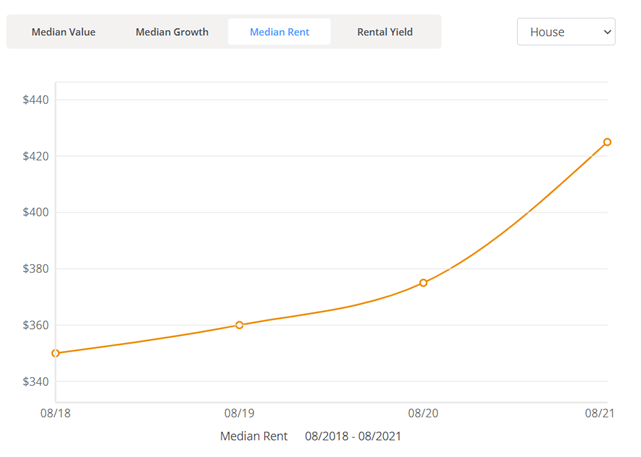
Click here to view the rental statistics report for Jun-Sep 23
Click here to view the rental statistics report for Sep-Dec 22
Click here to view the rental statistics report for Jun-Sep 22
Click here to view the rental statistics report for Mar-May 22
Click here to view the rental statistics report for Dec-Mar 22
Click here to view the rental statistics report for Sep-Dec 21
Click here to view the rental statistics report for Jun-Sep 21
Fun Facts
Infrastructure development of Seaford Heights began in early 2014 and the first permanent buildings (including an Aldi supermarket) were completed late in 2015. Aldi opened in February 2016.
The Fairmont Group was given the tender in December 2008 to develop the property, and planned to start in late 2009 however local opposition to the development stalled it for several years. Original plans called for 1,300 allotments and an approximate population of 4,500.
Some concerns have been raised with the council that the residential area will be sandwiched between two of Southern Adelaide's busiest arterial roads (Main South Road & Victor Harbor Road) and a dump.
* Information accurate as of September 2021 and provided by;
Australian Bureau of Statistics
RP Data CoreLogic