Local Information
Location
Seaford Rise is located south of Adelaide, approx 38kms from the Adelaide CBD.
It is bounded by Griffiths Drive and Robinson Road in the north, Victor Harbor Road, Ostrich Farm Road and the locality of McLaren Vale in the east, the suburb of Maslin Beach in the south, and Commerical Road in the west.
Demographics
Population; 6,099
Average age; 40 to 59
| Owns outright | Purchaser | Renting | Other | Not stated |
|---|---|---|---|---|
| 24% | 46% | 26% | 1% | 3% |
| Childless Couples | Couples with Children | Single Parents | Other |
|---|---|---|---|
| 34% | 46% | 18% | 1% |
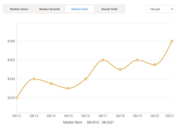
Click here to view the rental statistics report for Jun-Sep 23
Click here to view the rental statistics report for Sep-Dec 22
Click here to view the rental statistics report for Jun-Sep 22
Click here to view the rental statistics report for Mar-May 22
Click here to view the rental statistics report for Dec-Mar 22
Click here to view the rental statistics report for Sep-Dec 21
Click here to view the rental statistics report for Jun-Sep 21
History
At first, agriculture prospered and early European settlers quickly cleared native vegetation and planted cereal crops. Initially, wheat was the mainstay of the area. The success of the first two decades of farming was mirrored in the construction of a flour mill at nearby Old Noarlunga and the growth of that town.
The system of farming altered to a mixed form including sheep, poultry, small dairies and a diversity of cereal crops. The pattern proved to be profitable enough for farmers to survive on relatively small parcels of land - at least for a time.
While this form of farming continued for nearly one hundred years, by the mid-twentieth century, there were numerous land developments. This resulted from the movement of suburban population to the south of Adelaide and the rise of tourism along the beaches.
Agriculture dropped by the wayside as Government and private developers set aside land for urban expansion.
* Information accurate as of September 2021 and provided by;
Australian Bureau of Statistics
RP Data CoreLogic
-
Education
- Moana Primary School
- Noarlunga Primary School
- Old Noarlunga Primary School
- Port Noarlunga South Primary School
- Seaford 6-12 School
- Seaford K-7 - A Birth to Year 7 Campus
- Seaford Preschool
- Seaford Primary School
- Seaford Rise Primary School
- Seaford Secondary School
-
Recreation
- Karingal Reserve
- Moana Sands Conservation Park
- Onkaparinga River Recreation Park
- Port Noarlunga Aquatic Reserve

