Local Information
Location
Seaford Meadows is one of the newer suburbs in metropolitan Adelaide, south of the city.
It is bounded by the suburb of Port Noarlunga South and the Onkaparinga River in the north, the Onkaparinga River and Main South Road in the east, Seaford Road in the south, and Commerical Road in the west.
Demographics
Population; 3,847
Average age; 20 to 39
| Owns outright | Purchaser | Renting | Not stated |
|---|---|---|---|
| 9% | 46% | 44% | 1% |
| Childless Couples | Couples with Children | Single Parents | Other |
|---|---|---|---|
| 32% | 42% | 25% | 2% |
Market Insights

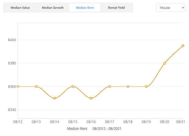
Rental Statistics
Click here to view the rental statistics report for Jun-Sep 23
Click here to view the rental statistics report for Sep-Dec 22
Click here to view the rental statistics report for Jun-Sep 22
Click here to view the rental statistics report for Mar-May 22
Click here to view the rental statistics report for Dec-Mar 22
Click here to view the rental statistics report for Sep-Dec 21
Click here to view the rental statistics report for Jun-Sep 21
Features
A smaller shopping complex opened in 2014 which includes a Woolworths, child care centre, restaurants/cafes and other small speciality shops.
* Information accurate as of September 2021 and provided by;
Australian Bureau of Statistics
RP Data CoreLogic
-
Education
- Moana Primary School
- Noarlunga Primary School
- Old Noarlunga Primary School
- Port Noarlunga South Primary School
- Seaford 6-12 School
- Seaford K-7 - A Birth to Year 7 Campus
- Seaford Preschool
- Seaford Primary School
- Seaford Rise Primary School
- Seaford Secondary School
-
Recreation
- Asor Park Reserve
- Christies Beach Caravan Park
- Karingal Reserve
- Moana Sands Conservation Park
- Onkaparinga River Recreation Park
- Port Noarlunga Aquatic Reserve

