Location
Reynella is a metropolitan suburb of Adelaide.
It is bounded by the City of Marion in the north, the Reynella Bypass Road (Main South Road) in the east, Sherriffs Road in the south, and Brodie Road and a line running continuous of Brodie Road in the west.
Demographics
Population; 4,752
Average age; 20 to 39
| Owns outright | Purchaser | Renting | Not stated |
|---|---|---|---|
| 32% | 45% | 21% | 2% |
| Childless Couples | Couples with Children | Single Parents | Other |
|---|---|---|---|
| 37% | 41% | 20% | 2% |
Market Insights

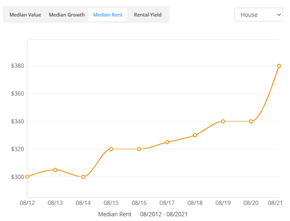
Rental Statistics
Click here to view the rental statistics report for Jun-Sep 23
Click here to view the rental statistics report for Sep-Dec 22
Click here to view the rental statistics report for Jun-Sep 22
Click here to view the rental statistics report for Mar-May 22
Click here to view the rental statistics report for Dec-Mar 22
Click here to view the rental statistics report for Sep-Dec 21
Click here to view the rental statistics report for Jun-Sep 21
Schools
Local schools for Reynella;
- Reynella South Primary School (R-7)
Transport Information
Reynella is primarily serviced by buses on the Adelaide Metro network. It is serviced primarily by South Road, Sheriffs Road exits on the Southern Expressway and Young Street.
Landmarks
An unusual landmark in Reynella is what is known as 'Junk Food Corner'. At a time when the fast food market was less saturated, the intersection of Main South Road and Pimpala Road had all four major fast food outlets:
McDonalds
Hungry Jacks
Pizza Hut
KFC
Currently on this intersection, there is McDonalds, KFC, Hungry Jacks, Fasta Pasta, Yiros King, Red Rock Noodle Bar, Domino's Pizza and a Caltex Service Station.
Reynella is also home to a smaller shopping precinct called Southgate Plaza. This is home to Coles & Target, and smaller retail shops.
* Information accurate as of September 2021 and provided by;
Australian Bureau of Statistics
RP Data CoreLogic